Resurfacing of Fletcher Ave. to begin April 20
April 17, 2020
Fletcher Avenue between North 58th and North 70th streets will be closed for a phased rehabilitation project. Sections will be closed at various times for the removal of railroad tracks, concrete repairs, removal of the existing surface and placement of new asphalt. This project is scheduled to be completed by Friday, May 22. For more information on this project, visit lincoln.ne.gov (keyword: fletcher).
Digital signs will alert travelers to upcoming work and closures. Travelers are encouraged to seek alternate routes. Drivers are reminded to exercise caution around work zones. Lincoln Transportation and Utilities (LTU) appreciates the public's patience during these projects.
Portion of Fletcher Avenue Project Rescheduled
September 23, 2019
The Fletcher Avenue resurfacing project between N. 56th and N. 70th streets has been rescheduled for spring 2020 due to utility work in the area by Black Hills Energy. The resurfacing was originally planned for this fall to coincide with the current replacement of the bridge on Fletcher Avenue just east of North 56th Street. Fletcher Avenue and the bridge are expected to reopen at the end of October. Some base repair work will be done this fall to have a better driving surface until resurfacing next spring.
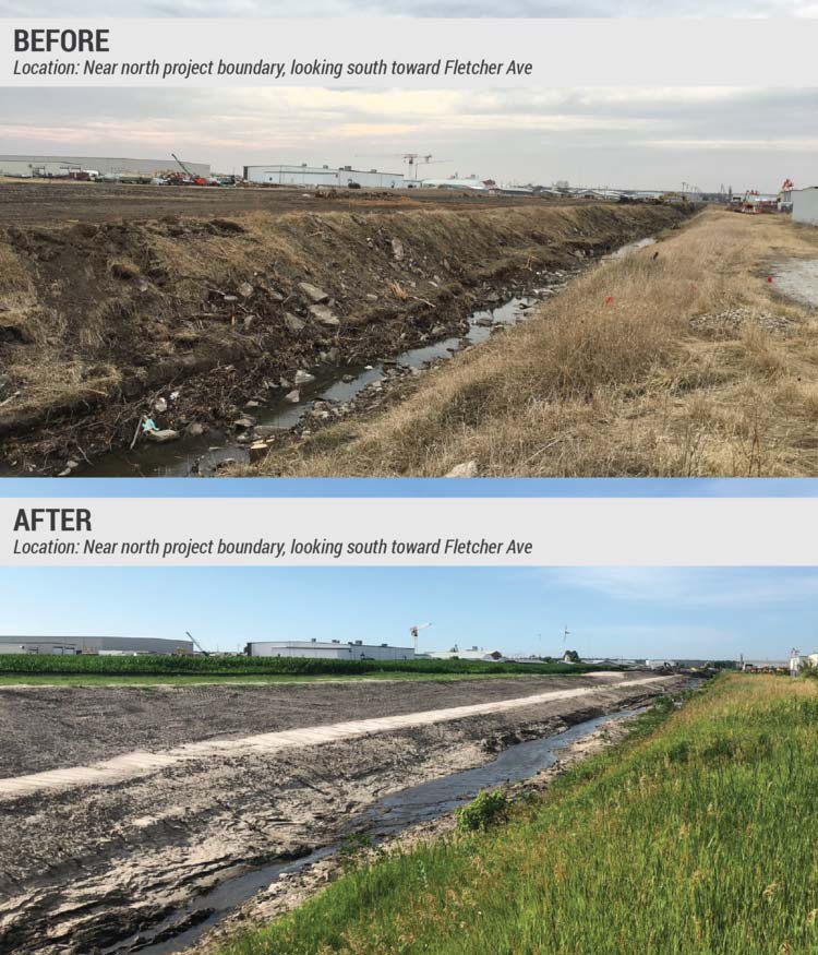
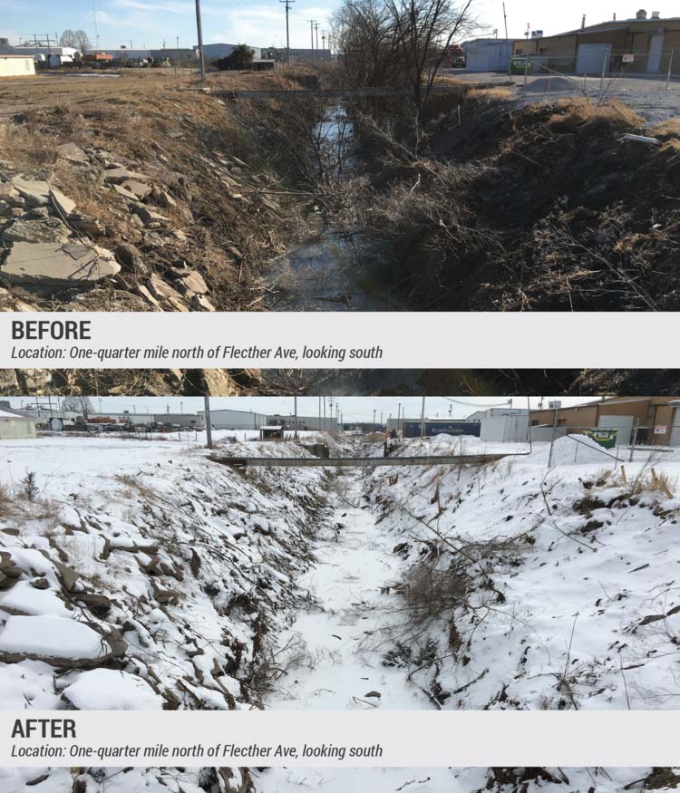
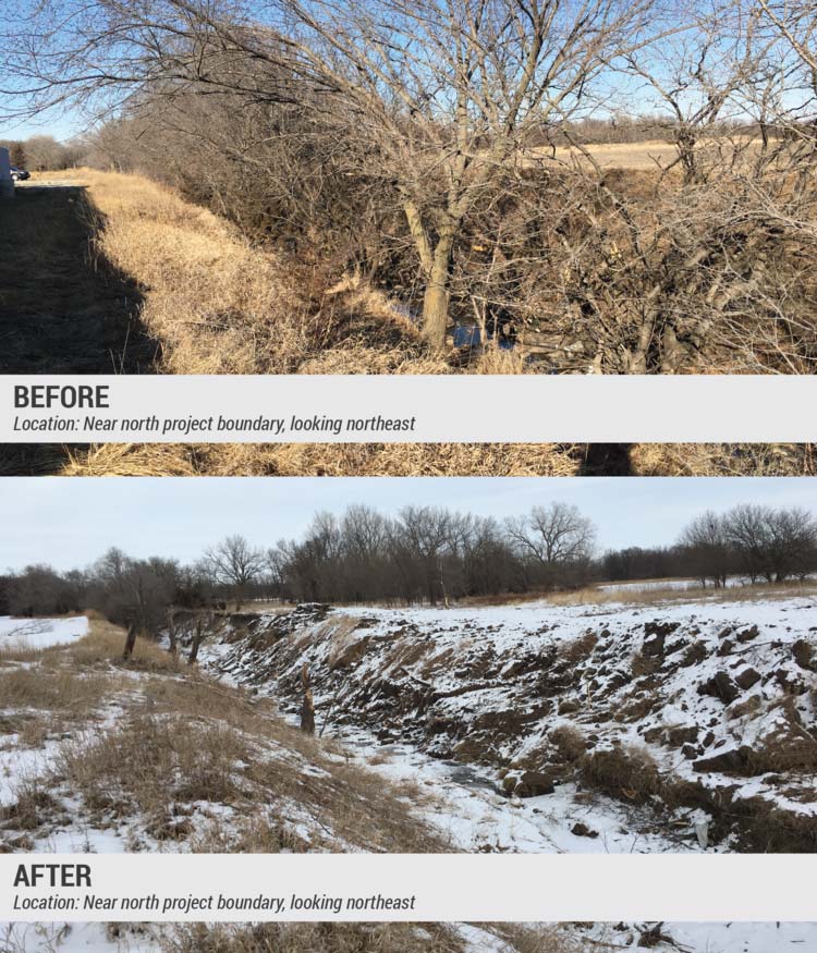
The bridge project will increase channel capacity and widen the channel through the commercial area east of N. 56th Street and north of Morton Street. The project also includes the reconstruction of storm drains and retaining walls and the stabilization of the banks to help prevent flooding and erosion.
More information on City watershed construction projects is available at lincoln.ne.gov (keyword: watershed). Current information on street closures is available at lincoln.ne.gov (keyword: closures) or through the Waze mobile app.
April 2019 Update
June 7, 2019
Construction began in March 2018 to widen portions of the drainage channel and stabilize streambanks to prevent erosion. To date, the excavation and grading of the channel is complete. Construction crews reached a major milestone in March 2019 when they fully removed the Fletcher Avenue bridge. A larger culvert will be constructed in its place to help improve water flow in the area.
Fletcher Ave. Bridge to Close February 11
January 29, 2019
Beginning Monday, February 11, the bridge just east of N. 56th Street on Fletcher Avenue will be closed to traffic. The bridge is expected to remain closed until July 2019. Drivers should use Cornhusker Highway (Hwy 6) as the alternate route. Access to businesses along Fletcher Avenue will be maintained via N. 70th Street.
A separate project to resurface Fletcher Avenue between 56th and 70th streets is being coordinated with this bridge work. The resurfacing will be completed in sections with temporary lane closures, and local access will be maintained as much as possible. It is anticipated the resurfacing will begin in April 2019 and completed in July 2019. Notice will be provided in advance of this work.
For more information, contact Ben Higgins, City Project Manager (bhiggins@lincoln.ne.gov, 402-441-7589) or Kevin Kruse, JEO Project Manager (kkruse@jeo.com, 402-474-8759).
Channel clearing and grading to begin south of Fletcher Ave.
August 14, 2018
Beginning this week, construction activities for the 56th & Moron Drainage Improvement Project will move from the north side of Fletcher Ave. to the south side. To date, and as can been seen from the Fletcher Ave. bridge near 56th St., most of the construction activity in the drainage channel has occurred north of Fletcher Ave. The contractor is ready to continue this work on the south side of Fletcher Ave. and would like properties owners in the area to be aware of the anticipated increase in activity. Construction efforts will include channel clearing, channel grading, pavement removals, and fence relocations.
It is anticipated that work to replace the Fletcher Ave. bridge near 56th St. will begin in early September. Additional information will be provided in late August when the construction schedule is more definite.
Crews hit milestone excavating, grading, and constructing drainage structures north of Fletcher Ave.
July 10, 2018
Construction efforts began in the drainage channel on the north side of Fletcher Ave. Much of the effort involved excavation of the channel, including the removal of volunteer trees, rip rap, pipe, and dirt. Along with this excavation, two manholes with pipes and one junction box with pipes were installed.
The next will be to excavate and grade the west side of the channel north of Fletcher.
Open House Set for Stormwater Improvement Project
March 6, 2018
The public is invited to an open house Thursday, March 15, on a stormwater drainage improvement project north of Cornhusker Highway near North 56th and Morton streets. The event is from 4 to 6 p.m. at Vital Services, 6400 Cornhusker Highway, Suite 250. The public may park in the south lot and enter through the east door of the main entrance. City staff, consulting engineers and contractors will be available to discuss the improvements and final construction plans and answer questions. No formal presentations are planned.
The drainage project includes widening the channel, reconstructing storm drains and retaining walls, and stabilizing the banks to help prevent flooding and erosion during rainstorms. Additional work includes resurfacing Fletcher Avenue between N. 56th and N. 70th streets.
The project is a joint effort between the City and the Lower Platte South Natural Resources District. It is 75 percent funded with a federal grant. The remaining cost is shared by the local agencies, and the City's portion if funded through the 2016 stormwater improvement bond issue.
For more information, visit 56thMorton.com, or contact Ben Higgins, Watershed Management (402-441-7589, bhiggins@lincoln.ne.gov). For questions about Fletcher Avenue, contact Erika Nunes at Public Works and Utilities (402-326-1037, enunes@lincoln.ne.gov). More information on City watershed construction projects is available at lincoln.ne.gov (keyword: watershed).
Construction underway on 56th & Morton Drainage Improvement Project
February 15, 2018
Construction of 56th & Morton Drainage Improvement project started with the removal of trees in the stormwater drainage channel west of North 56th Street near Fletcher Avenue. Stretches of the channel are almost unrecognizable from their pre-project condition.
Channel grading is anticipated to begin in March.
Tree Removal for Drainage Project Starts January 29
January 25, 2018
Trees in the stormwater drainage channel west of North 56th Street near Fletcher Avenue will be removed Monday, January 29, through the end of February. The work is being done to meet a Federal Migratory Bird Act April 1 deadline and precedes a larger drainage improvement project at N. 56th and Morton streets that begins in April and ends in 2019.
The project includes widening the channel and reconstructing storm drains and retaining walls to help prevent flooding and erosion during rainstorms. Additional work includes resurfacing Fletcher Avenue between N. 56th and N. 70th streets.
The project is a joint effort between the City and the Lower Platte South Natural Resources District. It is 75 percent funded with a federal grant. The remaining cost is shared by the local agencies. Stormwater Improvement Bonds from 2016 fund the City's portion.
For more information about the drainage improvement project or tree removal, contact Ben Higgins at Public Works and Utilities, 402-441-7589, bhiggins@lincoln.ne.gov. For more information about resurfacing Fletcher Avenue, contact Erika Nunes at Public Works and Utilities, 402-326-1037, enunes@lincoln.ne.gov. Learn more about City watershed construction projects at lincoln.ne.gov (keyword: watershed).
Second Open House Set for 56th and Morton Drainage Improvement Project
February 21, 2017
The public is invited to the second open house on a stormwater drainage improvement project in the area east of 56th Street and north of Cornhusker Hwy. The meeting is from 5 to 7 p.m. Tuesday, February 28 at Vital Services, 6400 Cornhusker Hwy, Suite 250. The public may park in the south lot and enter through the east door of the main entrance. No formal presentations are planned.
The 56th and Morton area experiences frequent flooding even during regular storm events. The drainage improvements, one of the City's 2016 stormwater bond projects, seek to reduce future flood risk and property damage for the area. Planned improvements include widening the channel, replacing the box culvert at Fletcher Avenue and rehabilitating the banks to prevent future erosion.
The project is 75 percent funded through a Federal Emergency Management Agency hazard mitigation grant. The City and Lower Platte South Natural Resources District are sharing the cost of the remaining 25 percent, with the City's funds coming from the 2016 stormwater bond. Construction is tentatively scheduled to start fall 2017.
Those attending the open house will have the opportunity to learn more about the project, review the draft improvement design and provide comments to help refine the next stage of design. City representatives and project consultants will be available to discuss the public's ideas and answer questions.
For more information, visit www.56thMorton.com, or contact Ben Higgins, Watershed Management, at 402-441-7589 or bhiggins@lincoln.ne.gov.
Open House Set for 56th and Morton Drainage Improvement Project
September 27, 2016
The public is invited to an open house Thursday, October 6, on a stormwater drainage improvement project in the area east of 56th Street and north of Cornhusker Hwy. The meeting is from 5 to 7 p.m. at Vital Services, 6400 Cornhusker Hwy, Suite 250. The public may park in the south lot and enter through the east door of the main entrance. No formal presentations are planned.
The 56th and Morton area experiences frequent flooding even during regular storm events. The drainage improvements, one of the City's 2016 stormwater bond projects, seek to reduce future flood risk and property damage for the area. Planned improvements include widening the channel, replacing the box culvert at Fletcher Avenue and rehabilitating the banks to prevent future erosion.
"This project is very important for area property owners and clearly demonstrated the need for the bond measure that passed last spring," said Ben Higgins, City Project Manager. "We are very happy to finally be working on a flood risk relief project for this part of our community." Higgins said the project was included in the 2012 stormwater bond issue, but was not completed due to federal funds being unavailable.
The project is 75 percent funded through a Federal Emergency Management Agency hazard mitigation grant. The City and Lower Platte South Natural Resources District are sharing the cost of the remaining 25 percent, with the City's funds coming from the 2016 stormwater bond. Construction is tentatively scheduled to start fall 2017.
Those attending the open house will have the opportunity to learn more about the project, review the draft improvement design and provide comments to help refine the next stage of design. City representatives and project consultants will be available to discuss the public's ideas and answer questions.
For more information, visit www.56thMorton.com, or contact Ben Higgins at 402-441-7589 or bhiggins@lincoln.ne.gov.