.
.
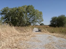
In 2010, the Lower Platte South NRD purchased the Allen Parcel. The Allen Parcel WMA is located between Branched Oak Road and Raymond Road, and is adjacent to the west side of 1st Street. Of the roughly 66 acres, 27 acres are Category 1 saline wetland and are identified as critical habitat for the endangered Salt Creek tiger beetle. Saline plants found on this site include the state endangered saltwort plant.
Thirty-three acres of the Allen Parcel lie within the Salt Creek floodplain. Neighboring properties are Little Salt Creek West Wildlife Management Area, owned by the Nebraska Game and Parks Commission, and Little Salt Fork Marsh Preserve which is owned by The Nature Conservancy. The WMA is open year-round for fishing, hiking, wildlife watching, camping and seasonal hunting and trapping.
 .
. 
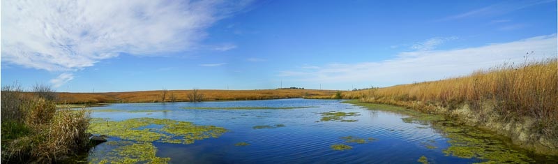
 A saline wetland just north of Lincoln and Interstate 80 along 27th street was acquired by the City of Lincoln as mitigation for the destruction of a smaller saline wetland filled when Capitol Parkway West bypass was constructed southwest of downtown Lincoln. Arbor Lake has public access, a parking area and benches to allow visitors to observe saline wetlands and the plant and animal life in the area.
In 2004, the City of Lincoln purchased an additional 69 acres of property to the east and south of the original Arbor Lake property. This purchase includes saline flats and buffer areas needed to protect these fragile natural areas. In total, Arbor Lake is now 132 acres in size.
Download the restoration final design(PDF, 369KB)
 The Frank Shoemaker Marsh was purchased in 2003. The site is 160 acres of land containing nearly 50 acres of eastern saline wetlands. The marsh provides a habitat for a variety of wetland plants and wildlife. Saline plants found on this site include the state endangered saltwort plant. When the City purchased the property it was a primitive, highly degraded complex. A wetland restoration construction began in September of 2006 and was completed in April of 2007.
The primary goals of the restoration project included enhancing and restoring degraded wetland systems, preventing further stream degradation, maintaining known wildlife habitats (specifically those of the Salt Creek tiger beetle), and complementing the restored wetland systems with native upland plant species. The plan included: sediment removal from wetland basins, reconstruction of existing berms and waterways to allow for better wetland functioning, installation of three in stream grade controls (called gabions) to maintain the stream grade and reduce erosion, creation of mud flats along the stream as Salt Creek tiger beetle habitat, removal of trees and shrubs from prairie areas, removal of invasive species, and replanting 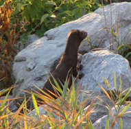 of prairie areas with a high diversity prairie seed mix. Five water level control structures were also installed, allowing the operator to control water levels between the three primary wetland basins that comprise the marsh.
The response by saline plants and native wildlife species has been positive. Numerous species of shorebirds, waterfowl, waders, and grassland birds have returned to the reconstructed habitat, including several species that had been absent prior to the restoration.
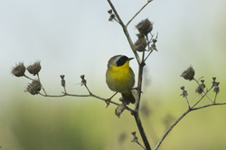
The City of Lincoln encourages nature-based recreational uses of the marsh. A trail winding through portions of the site, a handicapped accessible observation pier overlooking the greater marsh area, a wildlife-viewing pier, and a bridge over Little Salt Creek allow visitors to enjoy the beauty of the marsh and its wildlife up close and personal.
Time-lapse of Shoemaker Marsh
This time-lapse was taken from December 2013 through April 2014.
Frank Shoemaker Marsh Saline Wetland Totality
August 21, 2017
 Helmuth Marsh is located south of Mill Road and west of 14th Street and is owned by Pheasants Forever, Inc.
The 119 acre parcel was purchased in 2010. It contains 20 acres of Category 1 saline wetlands and in 2004, 40.7 acres were enrolled in the NRCS wetland reserve program.
 |
 |
| Pre-restoration 1992 |
Post-restoration 2006 |
The Jack Sinn Memorial Wildlife Management Area (WMA) located in southern Saunders and Lancaster Counties, Nebraska on both sides of Highway 77 south of Ceresco and east along Ashland Road and west along Little Salt Road. It consists of approximately 1,500 acres of marsh and open grasslands. The area was named in honor of Jack Sinn, a Wildlife Biologist with the Nebraska Game and Parks Commission who lived near the area and was killed in a plane crash while conducting a deer survey in 1979. The WMA is open to the public for hiking, nature observation and hunting. Only non-toxic shot is allowed. The area provides excellent waterfowl and shore bird habitat and viewing, particularly from late February into May. A good representation of grassland and wetland passerine species can also be found. Approximately 398 acres of Category 1 saline wetlands are located on the site.
Jack Sinn WMA recently underwent various wetland restoration measures in order to improve and expand existing wetlands within the Rock Creek watershed. Design improvements at Site 1 (just west of Highway 77, south of Ceresco) were constructed in late 1999 – early 2000 to address drainage from the wetlands adjacent to Highway 77. Other improvements have been completed or are in the process near 112th Street and Ashland Road. The Nebraska Game and Parks Commission has been actively restoring saline wetlands on the Jack Sinn WMA. The project consists of four phases; as of December 2008 phase's I and II were completed. Phase I included the installation of three in-stream weirs in Rock Creek and seven head-cut plugs that restored approximately 80 acres of wetlands. In Phase II, five new structures were installed and improvements were made to three of the existing off-stream structures which restored an additional 164 acres of wetlands. As a component of Phase III a total of eight new sites were identified for improvements including repair to one existing low-level dike and construction of head cut plugs, low head earthen dikes and silt control structures in and adjacent to the stream to restore the hydrology of the riparian zones and return it to a functional system. The project restored approximately 95 acres of saline wetlands. Funding for the restoration projects was provided by Nebraska Environmental Trust grants and with the Federal Section 319 funds available for the Eastern Saline Wetlands.
The property was purchased mostly in the 1980s and 1990s, using funding from the U.S. Fish and Wildlife Service (Pittman-Robertson funding) and the Nebraska Game and Parks Commission.
(images courtesy of Nebraska Game & Parks Commission)
 Located just east of Lincoln's Capitol Beach Lake, features a walking trail, which unlocks the treasures of this dense and rare saline wetland to the public. There is also a wildlife viewing blind overlooking two of several wetland ponds frequented by a wide variety of waterfowl. Parking area provided. Owned by the Lower Platte South Natural Resources District, the wetland was restored in the early 1990's.
In June 2005, a dedication was held to officially open Old Wyoming Bridge which spans an area in the northwest corner of the wetland. Once common in the mid-1800s, historians have tagged Old Wyoming Bridge, with its bowstring arches, as one of the last of its kind in Nebraska. In November 2003, Wyoming Bridge was removed from its original piers on Goose Hill Road, spanning Squaw Creek in Otoe County and stored nearby until it was moved to Lincoln and restored.

Owned by the Nebraska Game and Parks Commission, Little Salt Creek WMA consists of 256 acres and contains saline wetlands, open prairie, and grasslands. It is located 2 miles east of Raymond and one-quarter of a mile south of 1st and Raymond Road and follows Little Salt Creek to Mill Road near 14th Street in Lancaster County. The saline wetlands provide a habitat for a variety of saline wetland plants and wildlife. Saline plants found on this site include the state endangered saltwort. Hunting is allowed per the Wildlife Management Area regulations determined by the Nebraska Game and Parks Commission and only non-toxic shot allowed. A parking lot is located on the south boundary of the property along Mill Road. The property was purchased using funds from the Nebraska Environmental Trust and the U.S. Fish and Wildlife Service.


 .
. 
Little Salt Creek West WMA is located south of Branched Oak Road between NW 12th and 1st Streets. The 220 acre tract was purchased by the Nebraska Game and Parks Commission in 2009 using funds from the Nebraska Environmental Trust and the U.S. Fish and Wildlife Service. In 2010, a plant-community inventory was conducted, as well as, the construction of a parking lot on the north edge of the property adjacent to Branched Oak Road.
Little Salt Creek West WMA offers great views of the Little Salt Creek watershed and the surrounding saline wetlands. The lowlands of the WMA consist of Nebraska's eastern saline wetlands and supports saline plant communities including the state endangered saltwort plant. The uplands consist of a mix of native prairie, wildlife food plots, and restored prairie plantings.
Native wildlife including numerous species of shorebirds, waterfowl, waders, upland game birds, and grassland birds utilize the WMA. The area is open to the public for hiking, nature observation and hunting. Only non-toxic shot allowed.
 .
. 
 Since 2013, Owned by The Nature Conservancy the Lower Platte South Natural Resources District has owned the Little Salt Fork Marsh Preserve. The area consists of saline wetlands and open prairie. It is located 2 miles east of Raymond at the intersection of 1st and Raymond Road in Lancaster County.
Restoration for this site began in 1995 when the previous conservation owner The Nature Conservancy purchased a 60-acre tract. About this same time the Burlington Northern Railroad Company was in the process of creating the first wetland mitigation bank in the state. Together the two entities forged an agreement for the restoration, enhancement and expansion of the Little Salt Fork Marsh Preserve into a 180-acre nature preserve. Construction was completed in 1997.
In 2010, the Lower Platte South NRD purchased the Allen Parcel, which was adjacent to the north of the Little Salt Fork Marsh Preserve. This parcel consist of roughly 66 acres of which 27 acres are Category 1 saline wetland. Today, the parcel is included in the Little Salt Fork Marsh Preserve. The total area of this site is approximately 240 acres.
Little Salt Fork Marsh Preserve provides a habitat for a variety of saline wetland plants and wildlife. It is a frequent stop over for many shorebirds and migratory waterfowl. Saline plants found on this site include the state endangered saltwort plant.
The area is open year-round for fishing, hiking, wildlife watching, camping and seasonal hunting and trapping.


Little Salt Springs WMA is a 123 acre irregular tract of land located Southwest of NW 12th street and Branched Oak Road. The property was purchased by the LPSNRD in 2007 and contains the furthest north range of the Eastern Saline Wetlands in the Little Salt Creek watershed. The features of this property include nine acres of Category I and III saline wetlands, Little Salt Creek transverses the property for over .5 mile, contains approximately 20 acres of conservation reserve, has nearly 32 acres of freshwater wetlands and riparian areas, and over 65 acres are located in the floodplain.
In 2008, the 63 acres of former cropland on the site were planted with high-diversity mesic and upland prairie seed mix(PDF, 48KB) to provide a buffer for the wetlands and stream corridor on the property. The WMA is open year-round for fishing, hiking, wildlife watching, camping and seasonal hunting and trapping. A parking lot is located along Branched Oak Road on the northern border of the property.


The property consisting of approximately 150 acres is located on the north side of Salt Creek between approximately North 40th and North 48th streets and is owned by the Lower Platte South Natural Resources District. The property contains Category 1, Category 2, and Category 3 saline wetlands and critical habitat for endangered species.
The Marsh Wren saline wetland restoration project was completed in 2017. Funding for the project was provided by the LPSNRD and a 2012 Nebraska Environmental Trust grant for saline wetlands through the City of Lincoln. The Marsh Wren project design included the following measures:
- Wetland enhancement
- Excavation/sediment removal
- Sediment control structure construction
- Water level control structure(s)
- Saline water distribution system
- Vegetation management
- Supplemental water supply
- Grade control structure(s)
- Stream bank re-shaping
- Migratory bird habitat improvement
- Pedestrian access
The saline water distribution system was activated in the fall of 2017 and continually being monitored for water release and any necessary modifications.
Pioneers Park consists of approximately two acres of Category 1 wetlands and 30 acres of Category 3 wetlands. The Category 1 wetland is located between the Haines Branch Creek and Ben Verley Trail, west of the Haines Branch Creek bridge. The Category 3 wetlands are located at Muskrat Wetlands, Heron Wetlands, Wood Duck Wetlands and various low areas east of the bridge, between Haines Branch Creek and Ben Verley Trail. Trails have been marked for visitors on the Pioneers Park Trail Map(PDF, 1MB).
The mission of the Pioneers Park Nature Center is to interpret the natural history of Nebraska and the Central Great Plains; to promote the enjoyment, appreciation and awareness of our natural environment; to practice and foster a conservation ethic; and to provide a sanctuary for wildlife and a peaceful retreat for people.


Warner Wetlands is located near 98th street and Interstate-80 in Lancaster County. Saline meadows and associated plant communities are present on the site. The majority of the property is located within the established floodway and 100-year floodplain of Salt Creek.
In the late 1990's, approximately 23 acres north of the Interstate were donated in the name of Charles L. Warner for the preservation of wildlife and wetland restoration to the Lower Platte South NRD. An easement was also granted along Salt Creek at this time.
In 2004, the Lower Platte South NRD purchased an adjacent 140 acres (40 acres north of I-80 and 100 acres south of I-80) from the Board of Educational Lands and Funds. A 40 acre parcel south of Interstate 80 and adjacent to this property was then transferred from the City of Lincoln to the Lower Platte South NRD to complete the Warner Wetlands complex. The Warner Wetlands complex consists of nearly 200 acres.
Warner Wetlands is designated a youth mentor hunting site in Nebraska. In 2010, the LPSNRD entered into an agreement with the Nebraska Game & Parks Commission to allow youth mentor archery hunting on the north side of I-80.
 Located just south of Interstate 80 and east of 27th Street the Whitehead Saline Wetland is maintained by the Lower Platte South Natural Resources District (LPSNRD). The Whitehead Oil Company donated the 100-acre site to the LPSNRD in 1996. The site was successfully restored by the LPSNRD to preserve the rare saline wetlands and their ecosystems. The restoration project included the rehabilitation/replacement of an existing drop structure adjacent to Little Salt Creek and incorporating a water control structure to provide management capabilities that would support the existing wetland system. The project also included sediment removal along 28th street and raising the existing berm to improve access.
Whitehead Saline Wetlands contains a variety of saline wetland plants and animals, including the state endangered saltwort plant, which utilizes this vital habitat. In 2009, an observation deck was constructed along 28th Street, overlooking the wetland area. Informational panels and benches are located on the deck for visitors to learn about the saline wetlands and the wetland's native plants and animals, and to relax and view the wetland area.


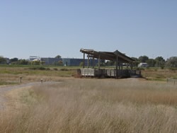
Among Zoetis's most notable environmental achievements are restoring 25 acres of degraded saline wetland. This includes a pavilion and a 3/4-mile interpretive trail. The pavilion offers multiple views of this restoration including saline wetlands and prairie landscape and provides information regarding the natural history of the area and the types of vegetation you will encounter as you walk along the trails.
The site is located on the southwest corner of 1st Street and West Cornhusker Highway. Please observe posted rules upon entering the site.
 .
.