Lincoln Parks and Recreation has embarked upon a master planning effort to look at the future of mountain bike facilities in the community. A working committee of mountain bike enthusiasts has been assembled to help the Lincoln Parks and Recreation Department determine what facilities are most needed and how they can be distributed around the community in order to provide equitable opportunities to all who are interested. Watch this webpage for updates on the master planning process.
Project Timeline:
September 2022 – April 2023: Public input gathered through surveys, communication with interest groups, open house, and public meetings.
October 2022 – February 2023: Working Committee meetings and drafting of Master Plan
March – April 2023: Public review and comment on draft Master Plan
May 11, 2023: Parks and Recreation Advisory Board open meeting to discuss and potentially take action on draft Master Plan.
Download the Mountain Bike Facilities Master Plan(PDF, 26MB)
The Mountain Bike Facilities Master Plan(PDF, 26MB) describes a road map to guide the development and management of mountain bike facilities in the City of Lincoln. Mountain biking enthusiasm, both nationally and locally, has been building for the past couple of decades. The city has long maintained natural surface trails in Wilderness Park, but the flat nature, frequent flooding, and flood regulations of that park make the kind of features desired by mountain bikers difficult to construct and maintain. In 2017 a group of mountain biking enthusiasts approached the Lincoln Parks and Recreation Department with a plan to construct a single-track facility in an underutilized area of Van Dorn Park. Once plans and agreements were finalized, this track was constructed by volunteers with the support of the surrounding neighborhood associations. While the Lincoln Parks & Recreation Department (LPR) does not have the resources to track park usage, observations and testimony indicate the community interest and visits to this park dramatically increased, demonstrating a demand for mountain biking facilities in the Lincoln area.
As is often the case when a new facility type is added to the park system, LPR planners investigated mountain biking, conducted site visits, and received professional training on the proper construction and maintenance of mountain biking facilities. After several years of successful partnership with Trails Have Our Respect (THOR) at the Van Dorn Park single track and development of the 2022 Single Track Trails: Improvements and Features, 2022 Edition (See Appendix A), LPR began a master planning process to look at community level of service and potential sites for the expansion of public mountain biking facilities in Lincoln.
The Mountain Bike Facilities Master Plan Working Group began a series of four meetings in October of 2022. They reviewed a large amount of information, conducted site visits to various park properties and reviewed public comment gathered at two points in the process. The goals of this Working Group were as follows:
- Discuss range of mountain bike facilities in Lincoln and the Level of Service.
- Recommend priority locations for facilities to serve the community equitably.
- Discuss different frameworks for design and management of mountain bike facilities.
- Discuss timing for projects and different funding strategies.
The members of this working group represent cycling enthusiasts, community organizations, and industry professionals. The Lincoln Parks and Recreation Department, and the City of Lincoln would like to thank these individuals for their dedicated service and the experience and insight they shared.
Members:
- Jason Brummels, Trails Have Our Respect
- Nathan Lowry, Pedestrian Bicycle Advisory Committee
- Jim Crook, Parks and Recreation Advisory Board
- Dwight Brown, Great Plains Trails Network
- Chris Spargen, Trails Have Our Respect
- Audrey Krimm, Nebraska DEVO
- Matt Avey, Lincoln Public Schools.
- Kris Sonderup, Cycle Works
- Jim Carveth, MTN Bike Community
- Yun Saksena, NE Interscholastic Cycling League
- Kyle Hansen, University of Nebraska-Lincoln
- Isaac Remboldt, Lincoln Bike Kitchen
- Tim Beckman, Star City BMX
- Audrey Saksena, Youth Representative
- Josalyn Poore, Youth Representative
The first step in the process to develop a master plan was to reach out to the Lincoln Community for information about current usage and the desire for future mountain biking facilities. Information gathered through an online community survey included questions such as – What types of facilities should we plan for? What do we need in order to support those facilities? What skill levels should be planned for?
The survey was held open from September 22 to October 12, 2022. A press release, Twitter and Facebook messages were used to promote the survey. Members of the Working Group were also asked to spread the word to user groups and other contacts. Responses were received from 540 individuals who indicated they represented approximately 500 additional mountain bikers in their households. Approximately 73% of the respondents were male, 24% female, and 2% preferred not to say. Respondents fell into a wide variety of age groups with the largest group (29%) being 36-45 years old. About 2/3 indicated they were at least proficient in their mountain bike skills and rode at least weekly. While there was not a high preference for trails close to home, there was preference for commuter and recreational trail proximity to make mountain biking easier for young people to access.
There was support for a wide variety of mountain bike facilities (types discussed below) with pump tracks, single track and skills courses receiving the most support. Some recreational/support facilities that were desirable for nearby access were picnic areas, disk golf courses, playgrounds and skate parks. Respondents indicated that off-street parking, a water source, bathrooms, trash receptacles and picnic tables were supporting services most desired at mountain biking facilities. Some of these services could be shared with other park facilities and in some cases would represent new services that would need to be established. The full survey report is attached to this document as Appendix B.
A second opportunity for public input was provided as the Working Group reviewed various potential single track facility sites. A virtual open house was held from January 9th through 23rd, 2023. Participants were invited to watch a short presentation and then to visit an interactive map where they could view the 19 sites being considered and leave comments. Participants were also invited to enter comments through a web portal. These comments were considered by Working Group members as they deliberated priorities for future single-track sites.
The Draft Mountain Bike Facilities Master Plan was released for public review and comment from March 3 through April 13, 2023. All comments were gathered and shared with the Parks and Recreation Advisory Board. After discussion with the facilities subcommittee, the Parks and Recreation Advisory Board hosted a public meeting on May 11, 2023, where they received public comment and took action to endorse the Mountain Bike Facilities Master Plan.
See what Lincoln had to say!
The Mountain Bike Facility Survey was available from September 22 – October 12, 2022. 540 community members took the survey! This information is used by the Working Group as discuss mountain biking facilities in Lincoln.
Review the Survey Responses(PDF, 635KB).
The Virtual Open House was available for comments until January 23.
The Mountain Bike Facilities Master Plan Working Group spent several months reviewing potential locations and narrowed the list to 19 park properties. On the interactive map, each area is marked with elevation lines and features color-coded slope information. Viewers may add their observations at each location.
Mountain Bike Facilities Master Plan Presentation
The origins of mountain biking can be traced back to every child that ever built a ramp out of a piece of plywood and a couple of cement blocks in their back yard. There is an adaptive and creative nature to the evolution from those ad hoc ramps to the complex and precisely engineered jumps of today’s mountain biking facilities. As the sport has evolved, standards and common naming have developed that inform this plan as well as the Single-Track Trails: Improvements and Features document referenced earlier. Ideally, over time the Lincoln community would develop a range of facility types to provide a wide variety of experiences at different skill levels.
Natural Surface Bike Trail
This is the simplest type of mountain bike facility and is a non-technical, often multi-use and multidirectional facility. A plain bike trail does not have any integrated features and typically has a smooth, wide trail surface. These trails can serve as an entry level into mountain biking. In Lincoln, natural surface trails can be found in Wilderness Park.
Single Track
Single track is trail that is designed to travel in single file and is typically 18 to 24 inches wide. Because the trail does not have adequate width for passing, users travel in a single direction. Single track can be single use or multi-use; however, when pedestrians are included in the design it is recommended that the direction of travel be opposite cyclists in order to assist with visibility. Single track trail can be any length but longer lengths are considered more desirable. At the writing of this master plan, there is one single track trail facility in Lincoln located in Van Dorn Park.
Single track may have features appealing to a wide variety of skill requirements. Typically, signage will identify the level of experience suggested for a given track or feature. Features are often constructed with varying height or grade to allow users of various skill levels to experience them by slightly varying the course followed. Features are described in more detail in the Single Track Trails: Improvements and Features, 2022 Edition (See Appendix A).
Skills Course or Track
Skills courses are designed to allow riders to experience and develop skills on different features. They are usually shorter than a single-track course and the features are more closely spaced in relation to one another.
Pump Track
A pump track is carefully designed to allow a rider to use gravity to gain height and pick up speed on decent. When well-planned and constructed riders can complete a pump track loop with very little added pedaling simply by using the exchange of gravitational and kinetic energy. Pump tracks can be designed for various skill levels and/or may include feature options to allow riders of varying skill to enjoy the same track.
Dirt Jumps
Dirt jumps are specifically designed for the rider to be able to “catch air”, often performing tricks while air born. Dirt jump tracks are typically flat overall and require the rider to attack the uphill in order to generate enough speed to leave the ground on the downhill side. Dirt jumps may be constructed as a looped trail.
Slalom Course
A slalom course involves two or more single tracks that are essentially identical and located side by side, usually on a downhill slope, to allow two riders to compete against one another.
One of the first and most important steps in master planning is development of a desired Level of Service for the community. The Level of Service, or LOS, refers to both the number and geographic location of facilities needed to serve the full community. This information helps to set goals and prioritize investments. In some cases, national data from similar communities can provide insights into the appropriate LOS. In other cases, particularly with emerging recreational activities, there may not be enough information from similar communities to be able to answer these questions.
Organized, publicly supported mountain biking is a recreational activity that is new enough that level of service information is not readily available. While some communities such as Bentonville, Arkansas, and Boulder, Colorado, have extensive systems, most other communities either have none or are just beginning to develop mountain biking into their parks and recreation systems. LPR and the Working Group members collaborated to develop a LOS goal specific to the Lincoln community.
The LOS speaks to two specific goals for mountain biking in Lincoln. First, providing recreational opportunities located equitably across the community. Second, providing experiences for all levels of skill so that the beginner has space to learn safely and build confidence and experienced riders have facilities that provide challenge and enjoyment.
Three Tier Level of Service
In order to provide a variety of mountain bike facilities equitably across the community, the following three tier approach to reach a Level Of Service over time is proposed:
Tier 1
A major Bike Park with a wide variety of mountain bike facilities to serve as a major event site and potentially attract users to Lincoln from around the region. This Bike Park could include:
- Single track
- Dirt jumps
- Pump tracks
- Skills courses
- Slalom courses
Supporting facilities such as off-street parking, restrooms, picnic areas, playgrounds and bike repair stations could also be included. The bike park should be located so there is (a) adequate access from major roadways and trails, and (b) nearby services such as restaurants and hotels in order to serve as a regional attractor.
Tier 2
A single track facility in each of Lincoln’s four quadrants (SE, SW, NE and NW). These facilities should have off street parking and access to nearby trails. Supporting features such as trash receptacles, water fountains, and picnic tables should be part of site development. Location near playgrounds, picnic shelters and other recreational activities such as skate parks and disk golf courses is desirable. Site selection and design should involve consideration of topography as well as soils.
Tier 3
Neighborhood mountain biking facilities as opportunities arise. Smaller scale mountain bike features and facilities could be located along wide trail corridors or within parks. These may include pump tracks and skill courses, single skill features, single-track trail adjacent to commuter and recreational trails or other such features. The scale of these additions should be such that it does not act as an attractor for the wider community but rather serves the smaller neighborhood area, except in cases where off-street parking is available. The siting of these facilities will be primarily dependent on the interest of the surrounding neighborhood and the appropriate characteristics of the site.
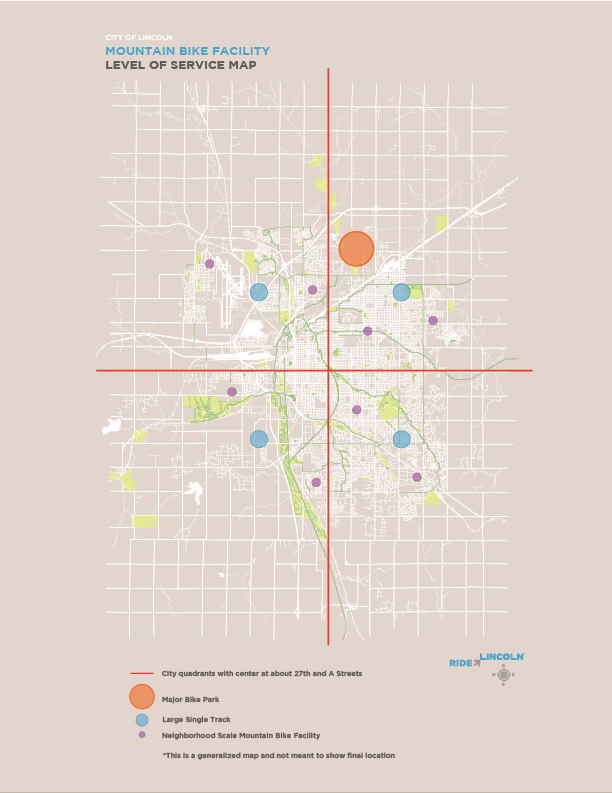
Level of Service Map(PDF, 3MB)
Tier 1: Major Bike Park
For the past decade, LPR has been planning for a bike park facility as part of the end use plan for the Construction and Demolition Land Fill at N. 56th and Fletcher Road. The Working Group confirmed this location as the preferred site for the Tier 1 facility. The site offers excellent access to Interstate 80 and NE Highway 77 as well as many hotel and restaurant services nearby on N. 27th Street and in the Havelock neighborhood. Commuter and recreational trail access is available along Superior Street and is planned on N. 48th Street and along Alvo Road in the future.
In 2015, Trails Have Our Respect worked with the International Mountain Biking Association to evaluate the site and prepare a preliminary layout of features. This conceptual layout will serve as a template moving forward.
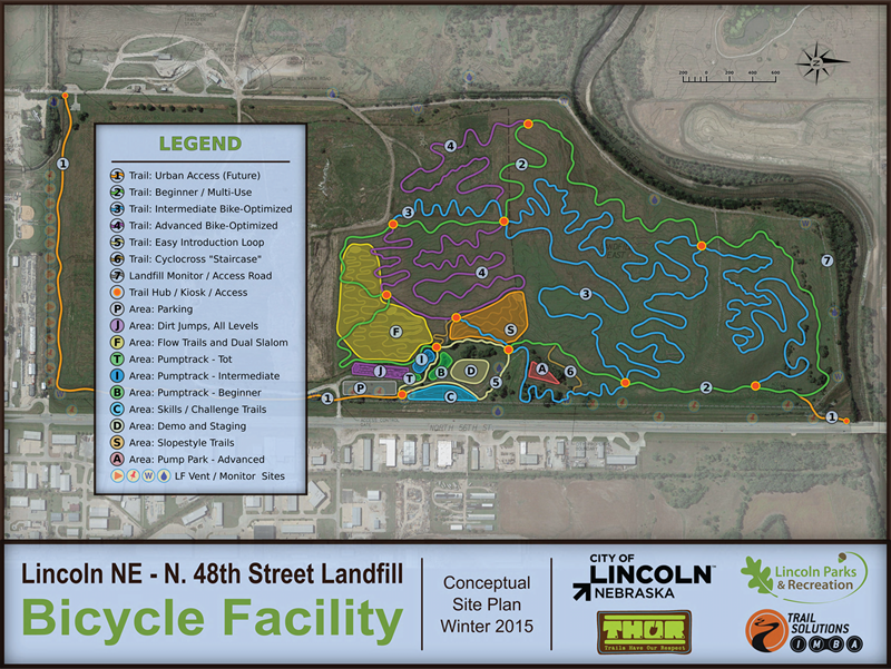
LBP-Conceptual-Site-Plan.pdf(PDF, 112MB)
Tier 2: Quadrant Single Track
A majority of the Working Group’s effort was toward selecting a site in each quadrant of the City where single track facilities might best be developed over time. This process started with an initial screening of all park properties three acres or larger in size. This set of properties was then reviewed to identify those sites that had an unprogrammed (no existing recreational uses) area of at least three acres. The resulting group was then screened to eliminate any areas that may already have been identified for other future recreational uses.
A list of 35 candidate sites was developed from this initial evaluation and presented to the Working Group. Each Working Group member selected one to three sites to visit in person and returned to the second meeting with their notes and observations from those site visits. During the meeting, each site was evaluated for general suitability for future development, facilities already in place and the characteristics of surrounding development that might support future single-track development. Each site was discussed and the various opportunities, as well as challenges, were reviewed. Working Group members then voted on whether to drop the site from consideration, gather additional information, or move forward with the site for additional analysis. A list of 19 potential sites emerged from this process.
Over the next two months, additional GIS analysis was performed on the 19 sites. Soils were evaluated for suitability and it was found that only a few isolated areas within some parks would be unsuitable, with all of those areas easily compensated for with proper design. Slopes were also analyzed and broken into three general groups: Flat (Red) being between 0% and 5%, Ideal (Green) being between 6% and 20%, and Steep (Yellow) being 21% or greater. A discussion of the selection of these categories is detailed in Slope Percentage Categories (Appendix C)
An interactive map was developed and both Working Group members and the general public were asked to share their comments on the suitability of each site. With the goal of selecting one primary priority site and one secondary priority site in each quadrant, Working Group members evaluated each site, discussed the relative benefits of each, reviewed comments that had been submitted by the public, and voted for priorities. The following sites were selected as the Primary and Secondary Priority in each quadrant of the City.
General note: Areas analyzed did not always include the full park site as many parks also include other activity areas. The area analyzed is preliminary and may need to be adjusted to accommodate more detailed design and access. While slope percentage is important when selecting a site, it is important to note that proper design can account for both Flat and Steep areas and the presence of these slopes, which are outside the Ideal range should not be reason alone for disqualifying a site. Primary sites refer to the highest priority area, secondary sites are considered slightly lower. Secondary sites could either serve as an alternative should the primary site be found to have challenges not yet realized, or they may serve as a future second single-track facility site if demand warrants.
Tier 2: Southeast Quadrant
Generally bound by A Street on the north and S. 27th Street on the west
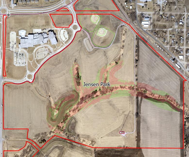
Primary Priority: Jensen Park
This community park located near S. 84th Street and Yankee Hill Road is in the early stages of development. Access from the Billy Wolff Trail and the Yankee Hill Trail is available. The Beal Slough Trail is planned for construction in 2024 and would provide a connection from the Boosalis Trail. In the future, the Wilderness Hills Trail is also planned to provide access and will include a grade separated crossing of S. 84th Street. Vehicular access to this location from S. 84th Street, Nebraska Parkway and the South Beltway is also good.
The park is approximately 190 acres in total and an area of about 29 acres, primarily along the wooded waterways, was the focus of this analysis. Approximately 42% of the area analyzed had slopes in the Ideal to Steep categories and the overall slope is 14.9%. Design will need to take into account waterway crossings and flood zones. A wide array of supporting services is planned for the park and a parking lot and ballfields are currently available in the northeast corner of the park. This park does have a master plan for future uses which should be reviewed and possibly amended to account for any single-track development.
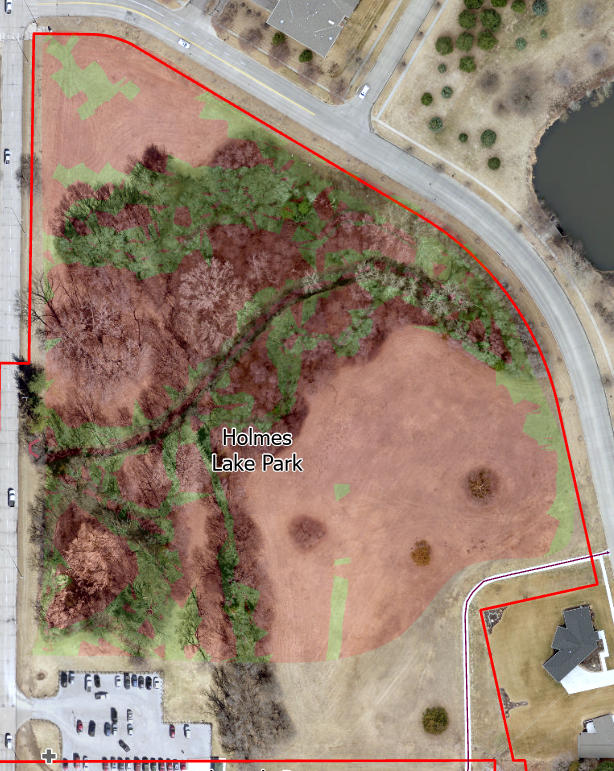
Secondary Priority: Holmes Lake Park East
This area within Holmes Lake Park (regional park) is located north of the Rickman’s Run dog facility parking lot. Access from the Billy Wolff and the S. 70th Street Trails is excellent. Vehicular access from S. 70th Street is good, although the current parking area would have to either be enlarged or a new parking area established south of Holmes Park Road.
The area analyzed is about 9 acres of wooded area with an average slope of 47.5%, and 32% of the area is in the Ideal or Steep range. The southwestern quadrant has floodplain which will need to be taken into consideration during design. There is currently a seasonal restroom available at the dog facility parking lot. All of the other facilities serving Holmes Lake Park are available to the west via a grade separated crossing underneath S. 70th Street.
Tier 2: Southwest Quadrant
Generally bound by S. 27th Street on the east and A street on the north.
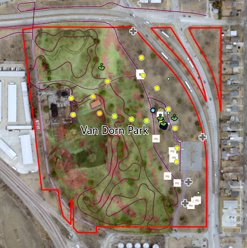
The Southwest Quadrant includes Van Dorn Park, site of the only existing single-track facility in a City park. This section identifies Van Dorn Park as the Primary Priority and Densmore Park as the Secondary Priority, although the priorities in this quadrant are more nuanced than others. Strictly considering the attributes and potential of these two parks, Densmore Park may have greater potential and offer more supporting services and better access. However, it is important that the existing single-track at Van Dorn Park be given due consideration in the development of future mountain biking facilities in the Southwest Quadrant.
Primary Priority: Van Dorn Park
This is the site of the only existing single-track facility currently located in Lincoln. It has been in operation through a cooperative agreement with Trails Have Our Respect (THOR) and appears to have grown in popularity over the past three years. Access is by the Bison Trail on the north, which is well connected to the Jamaica North Trail and the Salt Creek Levee Trail further to the west. A future connection, possibly by a combination of trail and on-street routes, is planned to link the Boosalis Trail to the east. A recently adopted amendment to the Van Dorn Redevelopment Plan includes a potential controlled crossing of 10th Street at High Street, which would improve pedestrian and bicycle access to neighborhoods east of the park. Vehicular access is at High Street from Nebraska Parkway on the east and connection to the West Bypass of Highway 77 is nearby. There is an existing paved parking lot interior to the park.
Van Dorn Park is a community park totaling 28 acres with the area analyzed being approximately 16 acres. A well established tree canopy provides shade and the site generally slopes downward to the west. Slopes in the Ideal range cover 76% of the area analyzed and the overall slope is 13.6%. There are restrooms located inside an enclosed rental shelter; however, they are not available unless the shelter is in use. A seasonal restroom, water fountain, playground and picnic facilities are all available within the park. A Master Plan is currently being developed to guide future improvements for this park and it has been identified as the potential location for a future botanical garden facility. Development of a botanical garden is the vision of a private interest group and at this time, no timeline has been established for its development nor has approval been granted by the City to proceed with any associated construction.
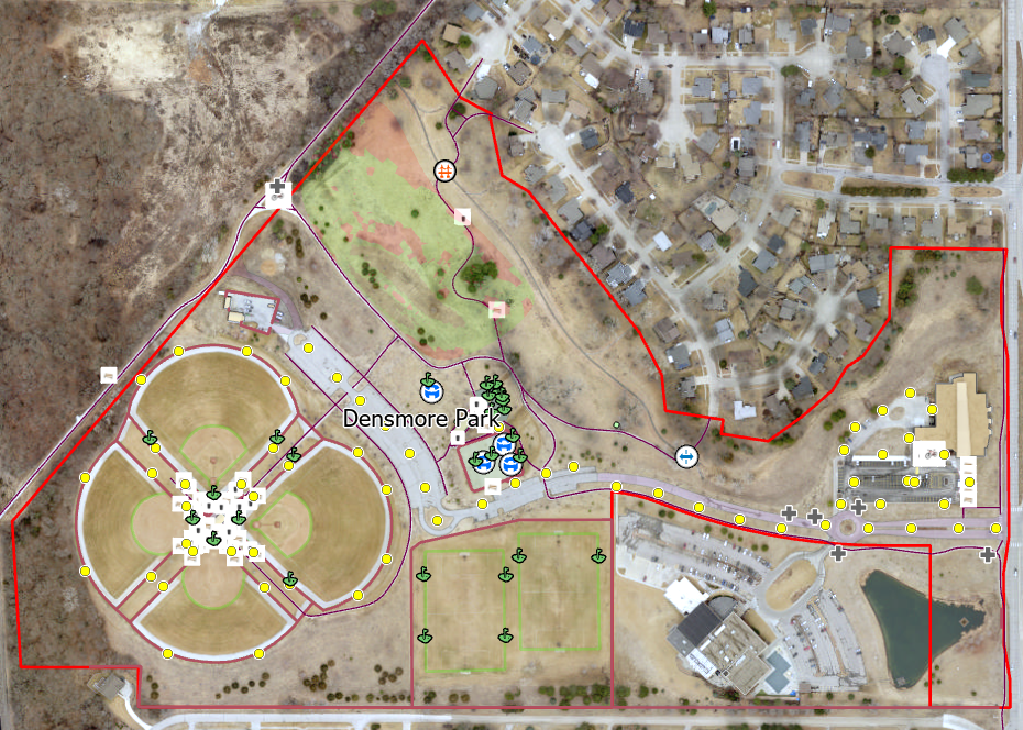
Secondary Priority: Densmore Park
This community park is located immediately west of S. 14th Street at Densmore Drive. Access from the Rock Island, Southpoint and Jamaica North Trials is excellent. The Rock Island Trail is planned to extend west, under Hwy. 77/2 to provide access to neighborhoods west of the West Bypass in the future. Vehicular access is from S. 14th Street with good connection to the South and West Bypasses of NE Hwy 2. There is a parking lot interior to the park; however, during use of the park’s four softball/baseball fields, the park parking lot and roadway tend to become congested.
Although there may be further opportunities in other parts of the park, the area analyzed was approximately six acres located north of the playground and tennis courts. There are some existing concrete trails that would need to be considered for possible relocation during design. Additional consideration and coordination will be needed to address the existing residential sites that back onto the area. The tree cover in this area is sparse and some early planting of trees could be done to begin to establish a tree canopy. Slopes average 17.9% and about 72% of the area slopes are within the Ideal or Steep range. There are excellent supporting services in the park including restrooms, solar charging station, bike fixit station, picnic facilities and playground.
Tier 2: Northwest Quadrant
Generally bound by A Street on the south and 27th/48th Streets on the north.
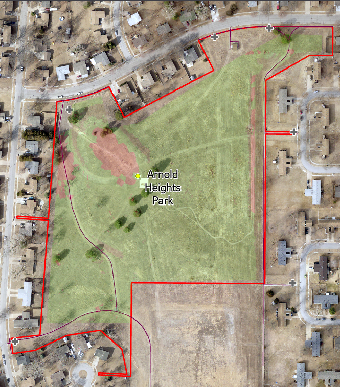
Primary Priority: Arnold Heights Park
This neighborhood park located in the Air Park Neighborhood is situated near NW 54th Street and W. Superior Street. Access will eventually be available from trails that are currently in various stages of development. The NW 56th Street Trail is planned to pass through the park as it connects at its northerly end to Arnold Heights Elementary School. At its southerly end, the NW 56th Street Trail will connect to West O Street where a trail and on-street bike facility along West O/P Streets will provide connection to the Salt Creek Levee Trail. Trail is also being constructed along West A Street where it will link to the SW 40th Street viaduct in the future. Vehicular access from Hwy. 6, Hwy. 34, and Interstate 80 is good.
The majority of the 17.6 acre park could be available for development of a single track facility. There is currently off street parking at a former school site south of the park and coordination with Lincoln Public Schools might allow for some additional use space. Tree cover is sparse and tree planting could be initiated to begin to provide some canopy for the park. Over 92% of the park falls within the Ideal or Steep slope range with the overall slope percentage being 16.7%. Perhaps the best feature of this park is the steep hill known as Tanker Hill and often used for sledding by the neighborhood. This hill brings opportunities for slalom and downhill development. It should be noted that development of single track should be designed to minimize interference with winter use as a sledding hill. There are scenic views of the downtown skyline from the park. Additional consideration and communication will be needed with the residences that back onto the park.
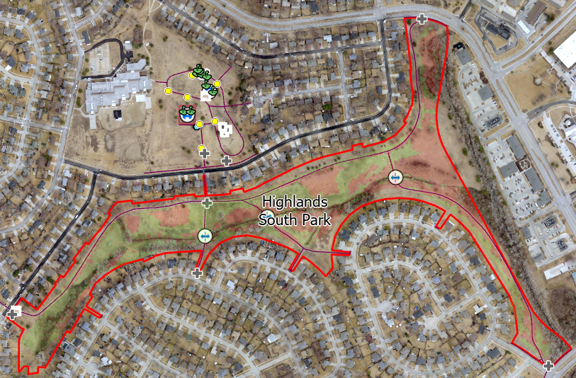
Secondary Priority: Highlands South Greenway
This conservancy area is located in the center of the Highlands Neighborhood, near NW 1st Street and W. Fletcher Ave., and generally serves as a wide commuter and recreational trail corridor. Good site access is available from the Superior and First Street Trails. A future trail connection across Hwy. 34 is planned to link to the Fallbrook and Highlands Trails. Vehicular access from Hwy. 34 and I-180 is also available. There is no parking available interior to the park and development of additional of parking may be challenging.
The area analyzed was approximately half of the 33 acre greenway. There is designated floodplain located at the eastern end of the greenway with a stream and commuter trail that restrict the usable area. There is good tree canopy in about 25 percent of the park area and the average slope of the site is 21.6%, with about 53% of the slope within the Ideal or Steep range. There are no park services within the greenway; however, Highlands Park is located immediately north of the greenway and includes a water source, picnic area and playground. There are also commercial businesses along NW 1st Street with a wide array of services. Additional consideration and communication will be needed to address the existing residential sites that back onto the area.
Tier 2: Northeast Quadrant
Generally bound by N. 27th/40th Street on the west and A street on the south.
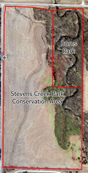
Primary Priority: Stevens Creek/Burns Park
This park property is located at N 98th and Adams Streets. Access by trail is not yet available; however, the Stevens Creek Trail is planned to follow the waterway from the Murdock Trail a half mile to the north and along Adams Street from the west. Vehicular access is via Adams or North 98th Streets. North 98th Street is currently a gravel county road but plans to upgrade to pavement are in process.
This community park is currently undeveloped and intended as a future community or regional park, depending upon future land acquisitions. It is about 80 acres in its entirety and an area of 14 acres was evaluated. Stevens Creek runs along the eastern border of the parkland. There is an existing small gravel parking lot off of N. 98th Street about 800 feet south of Adams Street. The Stevens Creek corridor is heavily wooded and has an overall slope percentage of 38.9% with 62% of the area slopes within the Ideal or Steep range. The northern end is primarily designated floodplain and floodway, with some additional floodway along the eastern side in the central portion of the property. Services are currently lacking and would need to be developed with a single-track facility.
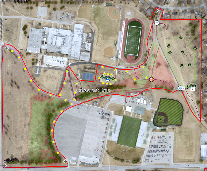
Secondary Priority: Seacrest Park
This community park is located adjacent to Lincoln East High School on the corner of S. 70th and A Streets. Access by trail is from the MoPac and 84th Street Trails and then neighborhood streets. The 70th Street Trail currently ends about a half mile to the south but is planned for extension to the site in the future. Vehicular access would be from 70th or A Streets. There is a very large parking lot for East High School use and to provide sport event parking.
The park is integrated into Lincoln the East High School campus and campus related functions/uses will need to be considered during design. The adjacency to the school provides opportunities for youth organizations, as well as for integration with cross country trails. There is some tree cover, particularly west of the parking lot. The overall slope percentage of the area is 10% with about 57% of the slopes falling within the Ideal or Steep range. There may be some potential to connect the east and west sides of the park, although traffic along the internal parking lot drive would need to be carefully considered.
Tier 3: Neighborhood Features and Facilities
Tier 3 of the proposed level of service envisions smaller scale facilities that would provide service more on a neighborhood level. These facilities should be designed at a size/scale that would not attract large numbers of users from outside the area unless sufficient off-street parking was available. Locations would be based on neighborhood interest and the commitment of a sponsoring organization to assist with construction and ongoing maintenance.
These facilities could include a pump track in a community park where parking is available, a single or couple of features such as a rock garden or skinny placed along the side of a concrete park pathway, or a single-track trail located adjacent to and within the corridor of a commuter trail. Design and feature type would be part of a conversation between the neighborhood, sponsoring organization, and LPR staff.
LPR may also include some of these features as new neighborhood parks are designed and developed. As the recreational interests of the community change over time, mountain biking activities, much like activities such as disk golf, skateboarding, and pickleball, are becoming more popular. LPR strives to monitor the popularity of these activities and to adapt park design to provide programming to meet the needs and desires of the community.
View Interactive Map
Interactive Map
Zoom in on this map to each of the sites and observe the area being discussed in more detail. As you zoom in you will see elevation lines. Zoom in closer and the space between the lines will show in three colors.:
- Red for areas that are relatively flat (0 – 5% slope)
- Green for areas that are between 5-20% slope which makes them ideal for single track
- Yellow which have slopes greater than 20%.
NOTE: Although the green is labled as “ideal” single track and other mountain biking facilities can be successfully designed on flat or steep (red or yellow) areas with a little extra care and perhaps importation of surface material. The slope information is part of what should be considered when recommending the best sites.
Design and construction of mountain bike facilities requires a skill set that continues to evolve. While many early features were designed through trial and error and personal experience, engineers are now engaged in the design of these features. LPR staff includes trained professionals that are able to assess structures during and after construction to determine when the services of a professional engineer is needed.
After researching standards proposed by the International Mountain Biking Association, conducting site visits to existing facilities in both Nebraska and Arkansas, and attending multiple training sessions, LPR staff have developed guidelines for the design and construction of mountain bike features. The Single Track Trails: Improvements and Features, 2022 Edition, is attached to this document and has been posted to the Mountain Bike webpage. It describes feature types, the design, construction and inspection requirements as the scale of features increases, and the point at which the assistance of a professional engineer must be sought. This document shall serve as the basis for design and construction and will be attached to any agreements with sponsoring organizations moving forward.
The maintenance of natural surface trails and features needs to be regularly conducted by someone trained for this work. In general, all natural surface trails and features should be inspected a minimum of every two weeks or after a rain event of 1inch or more. Signs of erosion, movement or decay of underlying wood, stone or other materials, and interference of vegetation are some of the key items to inspect. The Single Track Trails: Improvements and Features, 2022 Edition, includes inspection guides as well as sheets that are used to log inspections.
Currently, mountain bike facilities are managed as a partnership between a sponsoring organization and LPR. A legal entity in the State of Nebraska must be identified to act as the sponsoring organization. In addition, a “trail boss” should be identified to act as the point of contact for that organization. The Trail Boss is responsible for making regular inspections and reporting their results to LPR. The Trail Boss is also responsible for organizing regular maintenance that is conducted on the facility or feature. LPR has trained staff that perform quarterly inspections and help to determine the extent of repairs needed. In cases where a feature must be constructed with guidance from a professional engineer, an engineer also may need to be engaged to recommend maintenance and assess potential repair needs.
In the future, as more mountain bike features and facilities are developed within the Lincoln Parks system, it may be necessary to increase the number of professionally trained staff members to conduct inspections and maintenance. Alternatively, the services of a adequately qualified contractor could also be engaged to perform this work.
Final recommendations and a draft master plan will be developed and made available in March for public to review and comment. The final draft plan is expected to be presented to the Parks and Recreation Advisory Board at its public meeting in May 2023.