Wilderness Park

WildernessPark (horizontal).jpg

At 1,472 acres, Wilderness Park, located in southwest Lincoln, is the City’s largest park. As its name implies, the park is a natural area that straddles the Salt Creek floodplain and stretches from Van Dorn Street on the north to Saltillo Road on the South. The Park was established to serve as flood storage for Salt Creek and as a unique park experience for residents and visitors to Lincoln. The Park also serves as a conservation area and is home to many species of plants and animals. Visitors are encouraged to enjoy these creatures, but not to remove or disturb them in any way.

WildernessPark-Aerial-2.jpg

Wilderness Park includes picnic tables at 7 of its trailhead parking lots, and trail connections to facilities at Densmore Park at the 8th. Fishing with a State permit is allowed in all creeks. Restrooms are available at Densmore Park via a trail bridge connection just south of Warlick Blvd. Future seasonal restrooms are planned at three of the trailheads.

There are over 30 miles of multi-use trail in Wilderness Park shown on maps and signage as Red, Yellow and Green. Bicycles, cross country skis and pedestrians are welcome to use all trails, while horses are restricted to the Red and Green trails only. Trail users are encouraged to politely share the trails and to yield the right-of-way to others in the following manner: Cyclists yield to those on foot, all users yield to horses. Slower traffic should stay to the right when possible and make your presence known when approaching other trail users. Because it is a floodplain, Wilderness Trails can be frequently muddy, and users are asked to refrain from using muddy trails in order to protect their surface.

The Jamaica North Trail lies in the former Union Pacific railbed that runs along the east side of Wilderness Park in the area west of South 14th Street, and along the west side of the park as it continues south. The Jamaica North Trail links to the Homestead Trail south of Saltillo Road, then the Standing Bear Trail and Blue River Trail further south, reaching all the way to Marysville, KS.

Acres:  1,472.3 

Wildernesspark-web-20.jpg

Multi-Use Trails

Trails within Wilderness Park are designated as Red, Green or Yellow on signage and maps.

Red and Green Trails are open to all non-motorized users – bicycle, pedestrian, equestrian, cross country skiers, etc… Yellow Trails are not open to equestrian users, but all other non-motorized users are welcome. All users must follow the right-of-way protocols established for multi-use trails.

Equestrian users always have the right of way

  • When meeting horse riders on trails, make sure you are visible
  • Step to the right side of the trail and wait for the rider to acknowledge you
  • Wait for the rider to let you know it is OK to pass on the left

Cyclists must yield to horses as well as users on foot

  • Cyclists should let other users know when approaching from behind
  • Cyclists pass slower users on the left
  • Cyclists wait for horseback riders to indicate it is safe to pass on the left

Pedestrians be aware of other trail users

  • Scan trail ahead of you for approaching cyclists or horses
  • Slower traffic keep to the right side of the trail
  • If you must move to the left side of the trail, check for faster users approaching from behind

ALL users

  • Stay off muddy trails to keep from damaging the surface
  • Pack out everything you bring into the park
  • When using ear buds, lower the volume or remove one earpiece so you can listen for other trail users
  • If the trail is underwater or if there are hazards that cause you to turn back, be considerate of other users you may meet on your way back and let them know of the hazard ahead.
  • This park is home to many plants and animals. Do not disturb, collect, harass or destroy other living things unless part of a habitat management project
  • Want to do something extra? Consider bringing along a trash bag next time you go for a hike and pick up debris that may have blown or washed into the park
  •  

Wildernesspark-web-2.jpg Wildernesspark-web-3.jpg Wildernesspark-web-4.jpg

Navigating Wilderness Park

2021KioskWilderness.jpg

Wilderness Park trailheads include a kiosk with navigational information.  You can take a picture of the trail map on the kiosk, or scan the QR Code which will take you to the City’s trail map.  The trail map shows the Red, Green and Yellow trails.  Remember, horses are allowed on Red and Green trails only.  The map also includes numbered intersections to assist with navigation.  Special features such as water crossings, frequently wet areas, historical features, and parking areas are also shown on the map.  Finally, the map on the kiosk includes the mileage for each trail segment in the park.

2021WayfindingWilderness.jpg  

Inside the park are navigation signposts at each trail intersection.  These signposts have a cap with a number that corresponds to the numbered point on the map.  These numbers can help you locate yourself within the park.  They are also useful for communicating the location of any concerns you may want to share with Parks and Recreation, or to direct help to your location in case of an emergency.  It is good practice to be aware of the numbered points as you pass by them.

Signposts also include information about the trails.  By facing the direction in which you wish to travel, and checking the tags on the posts, you can determine the trail type of each segment.  Signposts that are nearby the Jamaica North Trail will include orange tags with “JNT” cut into them and an arrow directing you to that trail.  Signposts nearby parking lots will include blue tags with “P” cut into them indicating the direction to that facility.

By using the map tools and signposts you can safely navigate your way through the park, customize your route to meet distance goals, or create a navigation game for your family! 

Commercial Photography in the Park

Lincoln's parks and public gardens have provided beautiful backdrops for generations of family photos. When you or your photographer are taking pictures, we ask that you be mindful of, and minimize disruption to, other park users and garden visitors. Please also take care to avoid damaging any flowers, plantings, turf, or park property.

If your photo shoot is large and/or it could disrupt normal park or public garden operations, you make need to seek a Special Use Permit. If fees for photography services are collected on site, a Permit to Conduct Business may be required. Wedding reservations are available at our wedding designated sites. Please contact 402-441-7847, Ext. 0, or email parks@lincoln.ne.gov, for additional information regarding both Special Use Permit and wedding reservations.

Thank you and enjoy those beautiful pictures!


Wildernesspark-web-4.jpg

Stories of Wilderness Park

The following stories are displayed on the Trailhead Kiosks (TH) in Wilderness Park.

Lincoln Park and Electric Park (Day Camp TH1)

072-Falls-Lincoln-Park-Lincoln-Nebraska.jpg

The northern end of Wilderness Park was once the location of a corn grinding mill and a pond from which ice was harvested.  Lincoln attorney, and future Mayor, A. J. Sawyer purchased the property near 1st and Van Dorn streets and established Lincoln Park in 1887.  In 1906 Burlington Railroad purchased the site to operate the park and to access its wells to supply its steam engine roundhouse.  Lincoln Traction Company, operator of Lincoln’s streetcar system, purchased Lincoln Park in 1916 and reconfigured the dam allowing installation of a dynamo generator.  This generator supported illumination of the park, which became known as Electric Park, with incandescent and arc lighting.  Electric trolley cars connected to both Electric Park and Epworth Lake Park and thousands of visitors enjoyed the area.

In 1935, heavy rains led to flooding of the park and damaged many of the structures.  Competition from the popular Capital Beach amusement park combined with the economic challenges of the Great Depression led to Burlington abandoning the wells in 1935.  When Lincoln Traction Company closed Electric Park, the Cornhusker Council of Boy Scouts leased the land for a new permanent campground.  The council and volunteers improved to property with a swimming pool, longhouse and dining hall and called it Minis-Kuya.  The Cornhusker Council eventually moved the Boy Scout camp south of Humboldt and in 1970 the property was sold to Lancaster County to become part of Wilderness Park.

Epworth Lake Park (Epworth TH2)

The arched entryway before you is one of the few remnants of what was once known as Epworth Lake Park.  Established in 1903, this park was owned and operated by the Nebraska Epworth League of the Methodist Church.  Outdoor assemblies were held annually which drew thousands of participants.  Speakers came from all over, including Booker T. Washington, Carrie Nation, William Jennings Bryan, Theodore Roosevelt, and Howard Taft.  Shows included animal acts, magicians, story tellers, fireworks and music from the U. S. Army Band, Swiss bell ringers and performers such as Enrico Caruso.  Shows were so popular that as many as 25 street cars would line up to carry attendees back to Lincoln at the end of events.  The annual gathering was once called “the most largely attended church assembly in the U. S.”

Wildernesspark-web-23.jpg

Epworth Lake Park’s facilities included a 150-room hotel, a 60-bed dormitory, four restaurants, a grocery store, bakery, bookstore and post office as well as 500 cabins and canvas tents for rent.  A central feature of the park was Epworth Lake, a man-made lake surrounding “Oxford Isle,” on which a substantial cabin had been built.  The lake offered canoe rentals and featured “Venetian Nights” with decorated rafts and boats. 

In 1935, 14 inches of rain lead to heavy flooding of Salt Creek and destruction of most of the structures in the park.  A failed attempt was made to rebuild in 1940.  The Epworth Lake Park site was sold to Arnott R. Folsom in 1943, who deeded it to the City of Lincoln upon his death in 1970 with the express request that it be made part of Wilderness Park. 


epworth-park.jpg

Flood Control (Pioneers TH3)

The City of Lincoln had its origins in the Village of Lancaster, established in 1856 along the east banks of Salt Creek.  The availability of water, lumber along the streams, and most importantly surface salt deposits found in lowlands along the creek, attracted settlers to the area.  Salt Creek has shaped development of Lincoln ever since.  The meandering stream and adjacent low-lying land frequently flooded.  Following damaging floods in 1935 and 1942, a deadly flood in 1950 killed nine people and destroyed 600 homes and 80 businesses.  In 1958, the US Army Corps of Engineers began implementing flood control along Salt Creek.  Levees were constructed and the creek was channelized in an effort to save lives and property.

Channelization shifted Salt Creek from its previous meandering bed through Electric Park and Epworth Lake Park, pushing the creek between leveed banks along the former parks’ eastern edges.  In their review of a request for further channelization, the Corps noted that the natural functioning of the upper reaches of Salt Creek and its tributaries tended to reduce flood risk while their further development would exacerbate it.  As a result, the Salt-Wahoo Watershed District (now the Lower Platte South NRD), the City of Lincoln and Lancaster County joined together in assembling 1,470 acres of land to remain in permanent public open space, a combined recreational and flood-control asset called Wilderness Park.


Wildernesspark-web-1.jpg


Flora of Wilderness Park (First St TH4)

Wilderness Park has a wide variety of plant communities which reflect the ever-changing conditions of a floodplain and the history of human impact on the land. The pathway of Salt Creek and its tributaries has wandered over time leaving pockets of wetland habitat which is often without trees and characterized by reeds, cattails and sedges.  Periodic floods deposit sediment and create openings in the forest by knocking down older trees, providing nutrients for new growth and allowing sunlight to reach new seedlings.

As trees fall from old age, storm damage or flooding, the trunks are left in place to provide habitat for birds, reptiles, insects and other animals.  Wide varieties of fungi can be seen breaking down rotting wood.  The nutrients sequestered by fallen trees are returned to the plants and animals in the park.

Humans have shaped the area around Wilderness Park from their earliest presence.  Indigenous peoples used fire to manage large herds of grazing bison, preventing most trees from growing to maturity.  The meandering bends of streams like Salt Creek provided pockets where trees were able to grow to maturity.

Later, European settlers cleared woodlands to open farm ground and harvest timber.  They brought with them plants that reminded them of home - daylilies, rose shrubs, fruit trees, and others can still be seen in the park today.

Today, land managers in the park try to mimic some of these activities in order to maintain the wide variety of plant communities.  Grassland areas are managed with prescribed fire and mowing to prevent woody vegetation from colonizing.  Wetland areas have been re-established in many of the old oxbows of Salt Creek and its tributaries. Restoration of prairie and woodland is made part of any construction or invasive control project done in Wilderness Park.

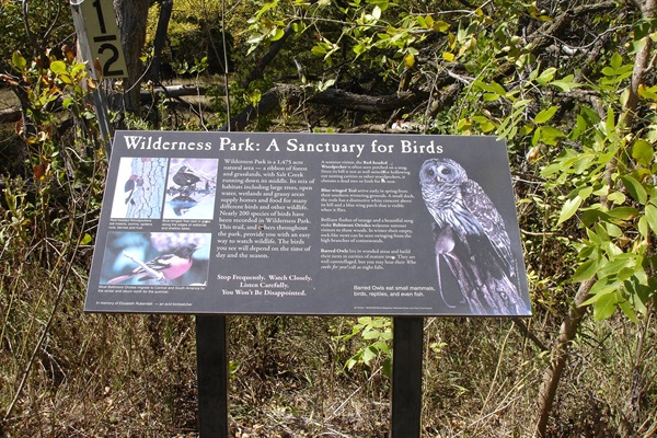
Birds of Wilderness Park (Old Cheney TH5)

Wilderness Park is a haven for migratory and resident birds!

The park’s many habitat niches provide food and safety year-round for hundreds of species of birds. But they can be difficult to spot if they are tiny like a warbler or hidden in dense vegetation like a towhee. Here are a few species of birds that you can find within the park with tips on where you might find them singing, eating, or nesting.

The high woodland canopy is a favorite spot to watch for migratory birds in spring and summer. Colorful warbler species are found here including American Redstarts and Tennessee Warblers, gleaning small insects from the under sides of elm and hackberry leaves. Watch for the striking blue of the Indigo Bunting high above the creek, singing its song of paired notes dripping downward in doubles. Red-eyed and Yellow-throated Vireos also perch in the canopy, matching the leaves with their olive and green backs.
LPR-WildernessPark-BirdInfo.jpg

Thickets in the understory and along the forest edge provide cover and fruit for many avian species all year round. Mimics like Brown Thrashers and Gray Catbirds can be found skulking, singing songs that sound like several other birds at once. Dogwoods, plums, and honeysuckles are also favorite spots to listen for the “Drink Your Tea” song of the Eastern Towhee and the bubbling babble of the House Wren. Red-tailed Hawk can be seen perching along edges of grassy meadows. . Open grasses provide feeding areas for several sparrow species including Clay-colored, White-throated, and Lincoln’s sparrows.

The open water and banks of Salt Creek are home to many wetland species including Great Blue Heron (which nest together in a rookery high in the canopy in the park) as well as Wood Ducks, Blue-winged Teal, and Song Sparrows. 

The woodlands are home to many birds year-round. Many woodpeckers, including Downy, Hairy, and Red-bellied Woodpecker, live and feed year-round in old trees in the park. The alarm call of “chick-a-dee-dee-dee” can be heard on almost any walk as Black-capped Chickadees spot danger and White-breasted Nuthatches “meep” in reply. 

Fauna of Wilderness Park (14th St TH7)

Wilderness Park provides important habitat for a wide variety of creatures.  The largest of these are the White-tailed deer which are common but can be difficult to see.  Keep your eyes on the trail and you will likely see their hoofprints, and maybe the dark brown to black oval shaped scat (distinguished from rabbit scat, which is round).  Other common mammals are rabbits, squirrels, racoon, opossum, and fox.  Most of these mammals live and raise their young within the park but may wander farther away to find food.

If you sit quietly along the banks of Salt Creek you may also see mink.  These small, dark colored members of the weasel family live close to the water’s edge where they hunt for fish, crayfish, frogs, birds and eggs.  Very occasionally bobcats have been seen in Wilderness Park and have even been known to raise their young here.  As with deer, it is more common to see the traces, footprints and scat, of mammals rather than the actual creatures.

Wilderness Park is also home to many amphibians and reptiles.  In the early spring, chorus frogs and leopard frogs can be heard on any warm day near the wetlands and shallow banks of the creek.  Tiger salamanders live mostly in soft soil but may be seen searching for insect meals in rotting logs.  Garter snakes, king snakes, bull snakes and others can sometimes be seen sunning themselves along trails or sunny banks.  Soft shelled and painted turtles sit along creek banks or on logs in the water.

Invertebrates are abundant and varied in the park.  Many pollinator species can be observed near blooming shrubs and wildflowers.  The soil is alive with nematodes, burrowing insects, earth worms and other subterranean creatures. Watch the surface of any body of water for water-striders, dragon and damsel flies, and boatmen who appear to paddle backwards through the water.  Rotting logs are a great place to look for ants, beetles, centipedes and grubs.  Mosquitoes and ticks are also abundant; protective clothing and frequent checks are recommended.

Village of Saltillo (Saltillo TH8)

As railroads developed south of Lincoln, small towns sprung up at regular intervals.  These towns provided access to rail transportation, trading posts for goods brought in by rail, and water towers to supply steam engines.  Two towns were developed on Salt Creek at what is now Saltillo Road.  On the west bank was the Village of Jamaica, and on the east bank, the Village of Saltillo.

Originally, this site was to be named Olathe, but in 1862 John Cadman built a road ranch called Saltillo Station.  The name “Saltillo” likely came from Saltillo, Mexico, but may have been chosen because it sounded like “salt,” referring to Salt Creek.  Saltillo’s location on Salt Creek was particularly attractive to town founders because it coincided with a branch of the Oregon Trail known as the Fort Kearny Cut Off.  This trail “cut off” 40 miles from the laborious trip by wagon between Nebraska City and Fort Kearny.  Travelers stopped in Saltillo and Jamaica to resupply and pick up mail at a post office. 

After the completion of the Transcontinental Railroad in 1865, the Oregon Trail, which powered the small town’s economy, became obsolete.  Frequent flooding, a lack of travelers and thus income, and the growth of nearby Lincoln sent the population, which never exceeded 50, into decline.  The Saltillo Post Office remained in operation until 1906.  The last visible remnant of the village, the grain elevator, was torn down in 1953.


Location

4700-4798 S 1st St, Lincoln 68510  View Map

Google Map
Tagged as: